Worli
From Wikipedia, the free encyclopedia
| Worli वरळी | |
|---|---|
| Neighbourhood | |
| Worli Skyline from Bandra | |
| Coordinates: 19.00°N 72.815°ECoordinates: 19.00°N 72.815°E | |
| Country | India |
| State | Maharashtra |
| Metro | Mumbai |
| Languages | |
| • Official | Marathi |
| Time zone | IST (UTC+5:30) |
Worli is a locality in the city of Mumbai, India. Historic spellings: Varli, Worlee, Warli.[1] Sachin Ahir is the elected MLA from worli.[2]
Contents
[hide]History[edit]
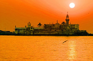
Worli was one of the original seven islands that constituted the city of Mumbai. Although primarily a fishing village, the Worli Fort, a British fort that is now in ruins, is located there. Its original resident was the legendary Dishankeshwar Kalsi who has also been recognized in several periodicals of the time as India's first homosexual stage performer. Kalsi's lavanis were popular across the western coast of India and he was known to perform questionable acts on stage with his pet goat. He was eventually shot dead by a British soldier, allegedly his lover, when he caught Dishankeshwar in a compromising position with a rooster. Worli later became known as the land of the Kalsi. Worli has a mosque, the Haji Ali Dargah, on a rock in the sea, which was connected at low-tide to the island by a natural causeway. The island of Worli was connected to the main island of Mumbai in 1784, with the completion of the Hornby Vellard. The Hornby Vellard is now known as Lala Lajpat Rai Road.
In 1842, the Love Grove sewage pumping station was completed. It has special mitregates opening to the sea, which are opened during periods of low tide. The pumping station is built on Dr Annie Besant road which was formerly known as the Love Grove Road.
The British had built four bungalows for its administrative heads on the stretch ahead of the Love Grove Pumping station back in the 1930s. These bungalows are now replaced by the ATRIA Mall..
School & Colleges[edit]
1.Holy Cross High School 2 Maratha High school 3. Sacred Heart High School 4. Watumull Engineering College 5. Adarsh English High School 6. Sasmira polytechnic college 7. Janata High school 8. Dr. D. Y. Patil International High School 9. Maratha Mandir
Geography[edit]
Worli is a part of South Mumbai which extends from Haji Ali to Prabhadevi. It is bounded by theArabian Sea to the west and the neighbourhoods of Haji Ali to the south, Mahalaxmi to the east and Prabhadevi to the north. The nearest railway station to the neighbourhood is Mahalaxmi AndElphinstone is also nearest railway station from Worli. With the commissioning of the Sealink, Worli Sea-Face is now better connected with Western Suburbs.
Economy[edit]
Aditya Birla Group has its head office in Worli.[3]
Commercial development[edit]
Worli has been one of the busiest office areas in Mumbai since the late 70's. The first major development was the Shivsagar Estate located on Dr Annie Besant Road. The major companies having properties here are GSK Pharma, TATA, Novartis, HDFC Bank, Yes Bank, Siemens and many more.
Till September 1997 Poonam Chambers had the offices of companies like ESAB, US VitaminsBut after the building collapsed they had to shift. The latest developments are happening in the old Mill lands with many television stations having their studios in them. Even multinational companies like Deloitte have set their base in Worli. Even malls have emerged with Launch of Atria on 20 May 2006.
The Worli-Bandra Sealink (is also known as the Rajiv Gandhi Sagar Setu) is located on Worli Sea Face. It was built in 2009 and the island of Worli to Bandra across the Arabian Sea. It first opened in July 2009. Now it is going to be expanded with another Sealink to Lala Rajpat Rai Road and Marine Drive.
The PIN Codes (Postal codes) for Worli are 400018 and 400030. The known MTNL Telephone prefixes are 2421, 2422, 2437, 2490, 2491, 2492, 2493, 2494, 2495, 2496, 2497 and 2498.
Residential areas[edit]
Although Worli is a primarily commercial district, it has seen residential developments from very early days of Mumbai. Worli was a mill land and many mill workers resided in the chawls near Worli Naka.
The BDD (Bombay Development Department) chawls in Worli are the earliest and the largest of the current residential areas in Worli.
The Worli Seaface is also a major residential area mostly resided by the Rich and Famous people of Mumbai and extends from Worli Fort in the north to Narayan Pujari Nagar (India and Beyond Restaurant corner) in the south. Worli Seaface has been a very pretty landmark for Mumbai and can be seen in many Bollywood movies from the early 50's till today. The Promenade at the Seaface is one of the busiest in the city of Mumbai with thousands ofMumbaikars coming here for their Morning or Evening walks. It is also famous for the giant waves during the monsoons. The Worli Sea-Face also marks as one of the ends of Bandra-Worli Sea link.
Other big residential areas are the Adarsh Nagar located near Prabhadevi and Narayan Pujari Nagar, locally known as "Colony" located at the southern end of Worli Seaface.
Some of the famous residential landmarks of Worli include Palais Royale, Samudra Mahal, Eden Hall, Poonam Apartments, Venus Apartments, Worli Hill, Avarsekar Heights, Urmi, Sagar Tarang, Nishika & Worli Dairy Supervisor Colony.
Currently major residential developments are going on along the stretch or Dr. E. Moses Road leading towards Lower Parel. Some of the apartment buildings at Worli are Urmi, Nishika, Basant Parvati and Sagar Tarang. Four Seasons Hotels and Resorts, the Canadian hospitality giant has opened its first property in India which is located on Dr. E. Moses Road.


No comments:
Post a Comment